Land Navigation - Practical
Watch for the Thorns
References: TC 3-25.26 | Land Navigation Website

Overview
You can be the best cadet at plotting points and knowing everything about maps, but that means nothing if you can’t find your points in the field.
Lieutenants are notorious for struggling with land navigation, but you don’t have to be one of them!
Yes, we have Garmins and GPS devices today, and you may use these tools in certain scenarios. However, knowing how to use a map and compass is still critical and expected of you as a platoon leader. This skill ensures you can navigate reliably in environments where technology fails, such as areas with poor satellite coverage or during equipment malfunctions.
This guide focuses on practical land navigation techniques to help you find your points effectively.
The Lensatic Compass
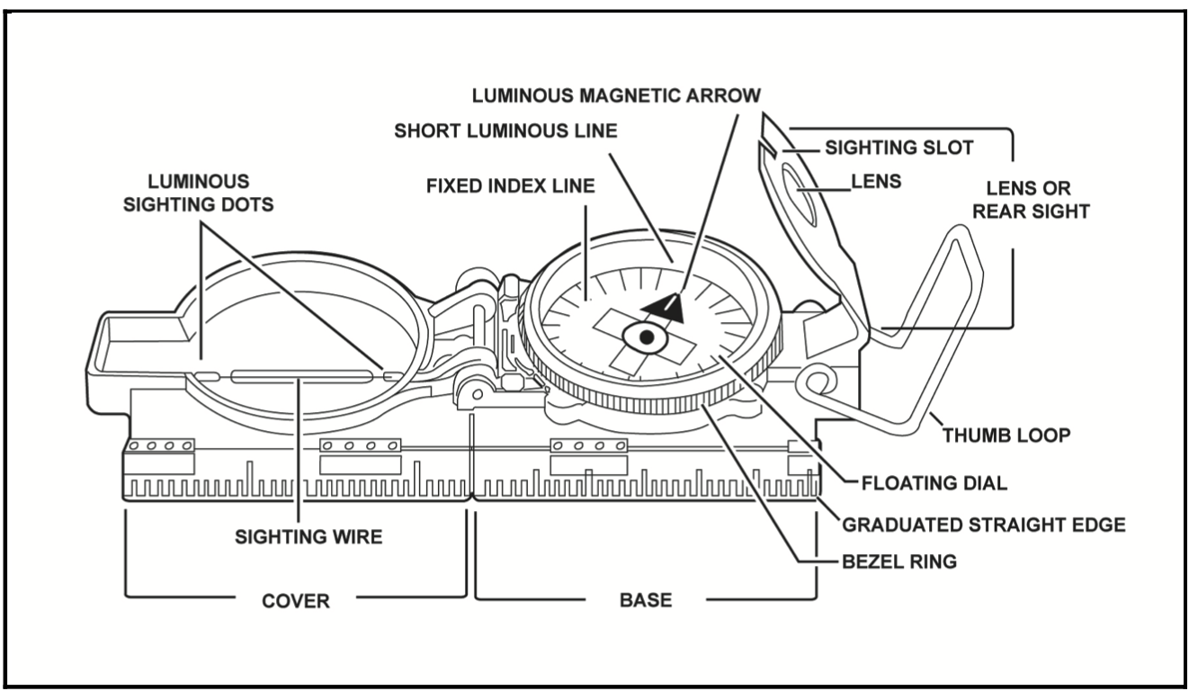 This is your best friend. Don’t lose it, or you’ll be lost!
Important
The lensatic compass is sensitive to magnetic interference. Keep it away from phones, watches, weapons, and other metal objects when taking a reading, as these can affect the azimuth and lead you in the wrong direction.
Reading the compass is straightforward: keep it level and steady to accurately indicate your direction. Use one of these two common holding techniques:
- Cheek Technique: Hold the compass to your cheek, aligning the sighting wire with the target for a precise azimuth reading.
- Center-Hold Technique: Hold the compass level at waist height, aligning your body with the target to read the azimuth.


Additional Tip: Always double-check your compass calibration before starting. Ensure the needle settles freely and points to magnetic north. If it sticks or behaves erratically, your compass may be damaged or affected by nearby metal.
Dead Reckoning
Dead reckoning involves keeping your compass out, tracking your pace count, and moving directly toward your destination. It’s the simplest form of land navigation but has limitations.
Challenges:
- Thick vegetation or obstacles can force you off course.
- Small deviations in direction can lead to significant errors over long distances.
Best Use: Use dead reckoning for short distances or flat, open terrain with minimal obstacles. Always maintain an accurate pace count (typically 100 meters per 100 paces, adjusted for your stride) and check your azimuth frequently.
Added Tip: To improve accuracy, periodically stop to verify your direction with the compass and adjust for any drift caused by terrain or fatigue.
Handrailing
For most land navigation scenarios, I recommend handrailing.
Handrailing involves following a linear terrain feature, or “handrail,” such as a trail, road, powerline, or river shown on your map. Instead of heading directly to your point, follow the handrail to an “attack point” as close as possible to your destination. From there, use terrain association or dead reckoning to reach the objective.
Benefits:
- Effective for covering long distances.
- Avoids dense vegetation.
- Reduces reliance on constant compass checks.
Execution:
- Identify a handrail on your map that leads near your point.
- Measure the distance along the handrail to your attack point and track it with your pace count.
- At the attack point, take a compass bearing to your final destination.
During CST, small trails known as “Cadet Trails” often lead directly to points. These eliminate the need for a compass if you know the relative location of your point and can find the trail.
Added Tip: Mark your map with key handrails and their distances before starting. Use a waterproof pen to annotate attack points and pace counts for quick reference in the field.
Bypassing Obstacles
When dead reckoning, you may encounter impassable vegetation or obstacles. To bypass them, use the “box method” by moving at right angles around the obstacle:
- Turn 90 degrees left or right and pace a set distance (e.g., 50 meters).
- Resume your original azimuth for a set distance to clear the obstacle.
- Turn 90 degrees in the opposite direction of your first turn, pacing the same distance as step 1.
- Resume your original azimuth to continue toward your point.
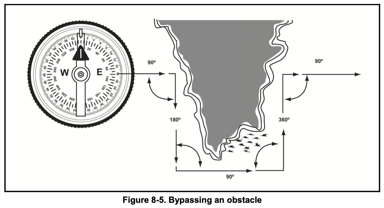
Caution: Be precise with your angles and pace counts. Even slight errors can lead you off course. Use a landmark or backstop (e.g., a hill or road) to confirm your position after bypassing.
Added Tip: Before bypassing, note a back-azimuth (original azimuth + or - 180 degrees) to ensure you return to your intended path accurately.
Terrain Association
Terrain association involves navigating by interpreting your map and surroundings, using notable features like roads, hills, man-made structures, or rivers.
How It Works:
- Identify prominent features on your map and locate them in your environment.
- Use these features to orient yourself and guide your movement.
- Adjust your path based on what you see, checking the map frequently.
Advantages:
- More forgiving than dead reckoning, as you can verify your position with visible landmarks.
- Less reliant on precise compass bearings, though a compass can help confirm direction.
Challenges:
- Misreading the map or misidentifying features can lead to errors.
- Requires good map-reading skills and situational awareness.
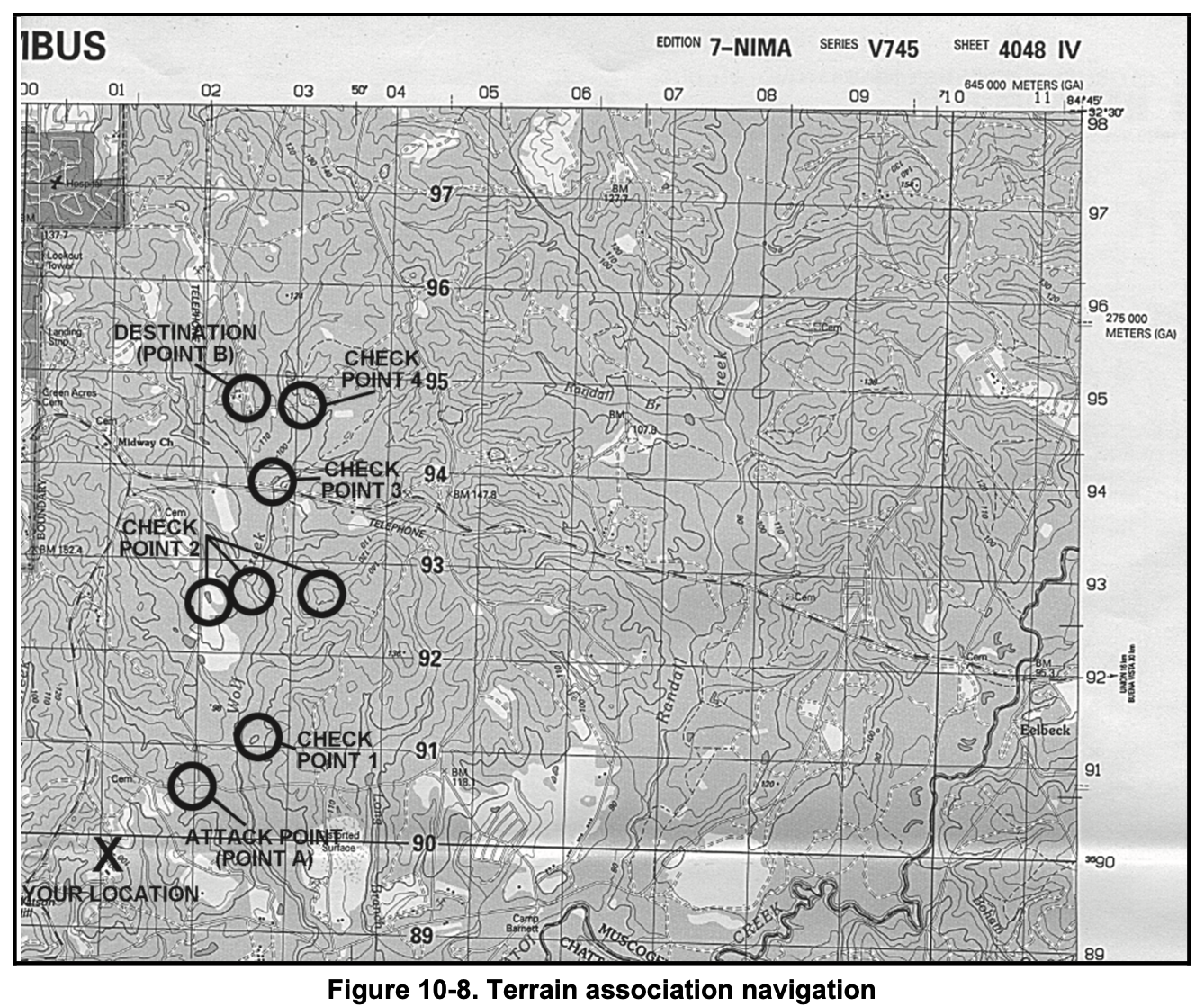
Added Tip: Practice map orientation by aligning your map with the terrain using your compass. Fold your map to focus on your area of operation and keep it accessible in a waterproof case.
Nighttime Land Navigation
Night navigation is significantly harder due to limited visibility. You cannot use a red lens flashlight, as it may compromise your position, so rely on ambient light, ideally from a full moon.
Best Techniques:
- Handrailing: Follow trails or roads to minimize compass use and stay oriented.
- Dead Reckoning: Use precise pace counts and frequent compass checks, but only over short distances due to increased error risk.
Added Tips:
- Use reflective tape or glow sticks (if permitted) to mark your path for backtracking.
- Move slowly to avoid disorientation and check your map under minimal light to preserve night vision.
- Memorize key terrain features before dark to anticipate landmarks.
Resection
Resection allows you to determine your current location using two known points visible in the field and on your map.
Steps:
- Identify two distinct landmarks (e.g., hilltops, buildings) on both your map and in the terrain.
- Shoot a magnetic azimuth to each landmark using your compass.
- Convert the magnetic azimuths to grid azimuths (using the map’s declination diagram).
- Plot the grid azimuths on your map by drawing lines from each landmark backward (back-azimuth: azimuth + or - 180 degrees).
- Your location is where the two lines intersect.


Added Tip: For greater accuracy, use three landmarks if possible. The intersection of three lines forms a triangle, and your location is likely near its center. Ensure landmarks are far enough apart to avoid parallel lines, which reduce precision.
Conclusion
Mastering land navigation requires practice with both map and compass. Combine techniques like handrailing, terrain association, and dead reckoning based on the terrain and conditions. Always double-check your map, compass, and pace counts to avoid errors. With enough field practice, these skills will become second nature, setting you apart as a competent platoon leader.